TOMERONG is located on the New South Wales South Coast 20 kilometres south of Nowra and just east of the main south coast road, the Princes Highway. It is situated in the city of Shoalhaven about eight kilometres inland from the western shores of Jervis Bay. The village is 48 metres above sea level and is overlooked to the north by Tomerong Mountain Trig Station, Tomerong Hill, at 111 metres. The settlement is concentrated on a north to south spur of this hill, which runs 2 kilometres south down to Tomerong Creek, 20 metres above sea level... (extract from Tomerong Local History)
Tomerong, geologically, lies near the southernmost extremity of the Sydney Basin, a saucer of rock formations. To the north and west of the Tomerong area the rock comprises mainly Nowra Sandstone that thins, changing to Wandrawandian Siltstone in the south and east. The Sandstone comprises sand sized particles of sedimentary rock whilst the Siltstone is a finer grained sedimentary rock. The Wandrawandian Siltstone sits underneath the Nowra Sandstone. Both rocks contain marine fossils.
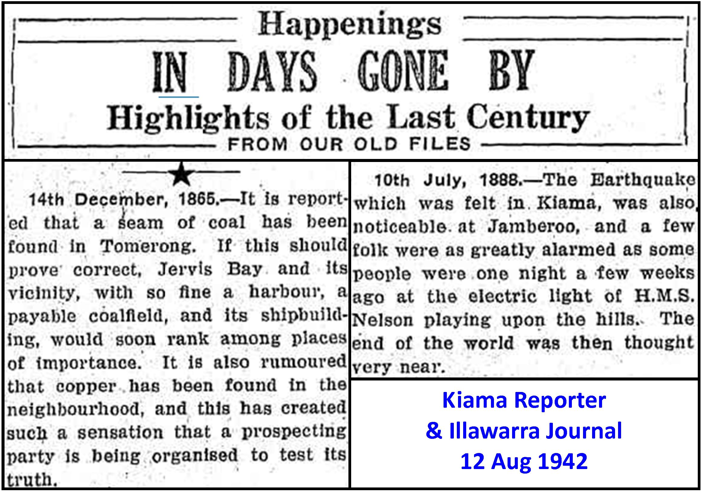
Coal was known to occur beneath the sediments of the Sydney Basin. Shipwrecked sailors and escaped convicts had reported the existence of coal, both north and south of Sydney, in the last decade of the 18th century. Later, coal was observed as outcrops in the Clyde Valley. On 14 December 1865 the 'Kiama Independent' reported that a coal seam had been found at Tomerong. The search for coal resulted in a bore being sunk by John Maclean & Company on 1 January 1891. The bore was located just over 5 kilometres west of the current Turpentine Road/Princes Highway intersection on the southern side of the road and was drilled to a depth of 437 metres. After drilling through 48 metres of Nowra Sandstone, 132 metres of Wandrawandian Siltstone was encountered which overlaid 80 metres of Snapper Point Sandstone. Beneath this was found 147 metres of Pebbly Beach Formation, which consists of layers of siltstone and sandstone with occasional course grained gravelly sedimentary rock (conglomerate). Coal was intersected at a depth of 406 metres and extended in bands for a further 25 metres... (extract from Tomerong Local History)
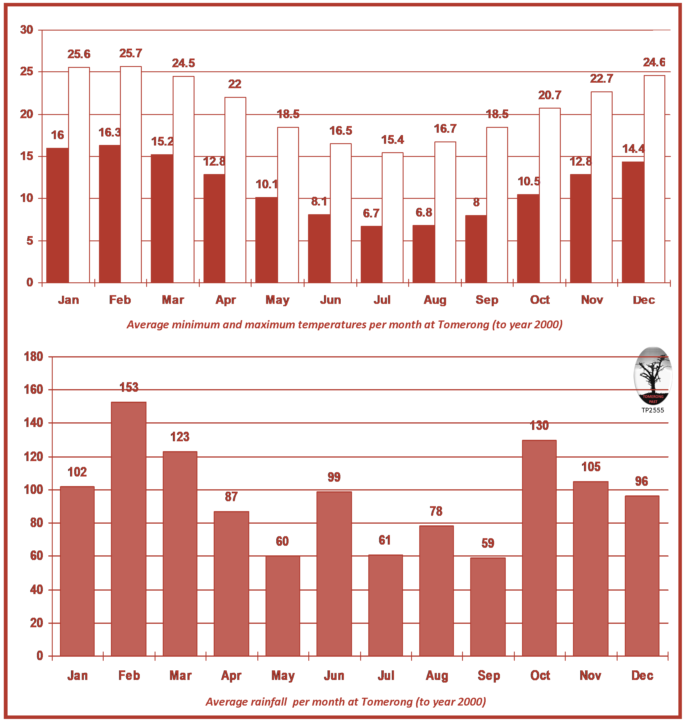
In 1915 John Grant, the Tomerong Public School teacher, recorded monthly rainfall figures. The following year was a very wet year and Grant recorded rain on 185 days. Current records indicate that rainfall occurs on an average of 132 days a year with a mean annual rainfall of 1158 mm. The average rainfall for each month is shown below (up to year 2000). Climate records have been recorded at the Naval Air Station located 13 kilometres north-west of the village. Maximum and minimum average daily temperatures for each month are listed below (up to year 2000)... (extract from Tomerong Local History)
Flora and fauna surveys were carried out in 1990 as part of the Bypass Environmental Impact Assessment. The survey reports contain extensive species lists. The sandstone soils in the higher areas support dry open low woodland with young trees usually less than 15 metres (1990). Dominant tree species are Scribbly gum, Red bloodwood, Turpentine, and White stringybark. More isolated are Spotted gums, Blackbutt, Sydney peppermint and Silvertop ash. The understorey and ground cover consists of Acacias, Blady grass and Bracken fern.
Taller forests occur on the slopes and the valley floors where the sandstone is replaced by clay. On the ridge tops are taller Blackbutts and Spotted gums whilst Bangalay and Sydney blue gums appear on the lower slopes. Mahogany occurs where the sandstone changes to siltstone and gaps in the canopy are filled with Wattles. The understorey is more diverse in the upper reaches of the valleys and the trees are taller. On some valley floors the timber has been managed for harvest and the understorey is sparse. The upper gullies have a tree canopy of Blackbutts, Sydney blue gums and Turpentines. Below this are Cabbage palms, vines and a dense ground cover of ferns and moss. The vegetation near the creeks at the lower altitudes on the alluvial soil consists of a sparse Eucalypt canopy with a second lower, more closed canopy over rainforest type vegetation.
The flora surveys found that most of the survey area had been altered by selective logging and clearing for grazing. The riverine vegetation on the flood plains around the creeks was less affected whilst the upper gullies had been affected by logging and fire. The surveys identified one plant occurring on the banks of the creeks that was considered endangered and liable to disappear from the wild within 10 to 20 years. The Brush cherry (Syzygium paniculatum) is an evergreen tree with glossy leaves growing to approximately 11 metres. Its leaves are a coppery colour, when young, turning a deep green. It has fluffy, white flowers in summer followed by fragrant, rose purple fruits. Terrestial orchids also occurred along the creek areas.
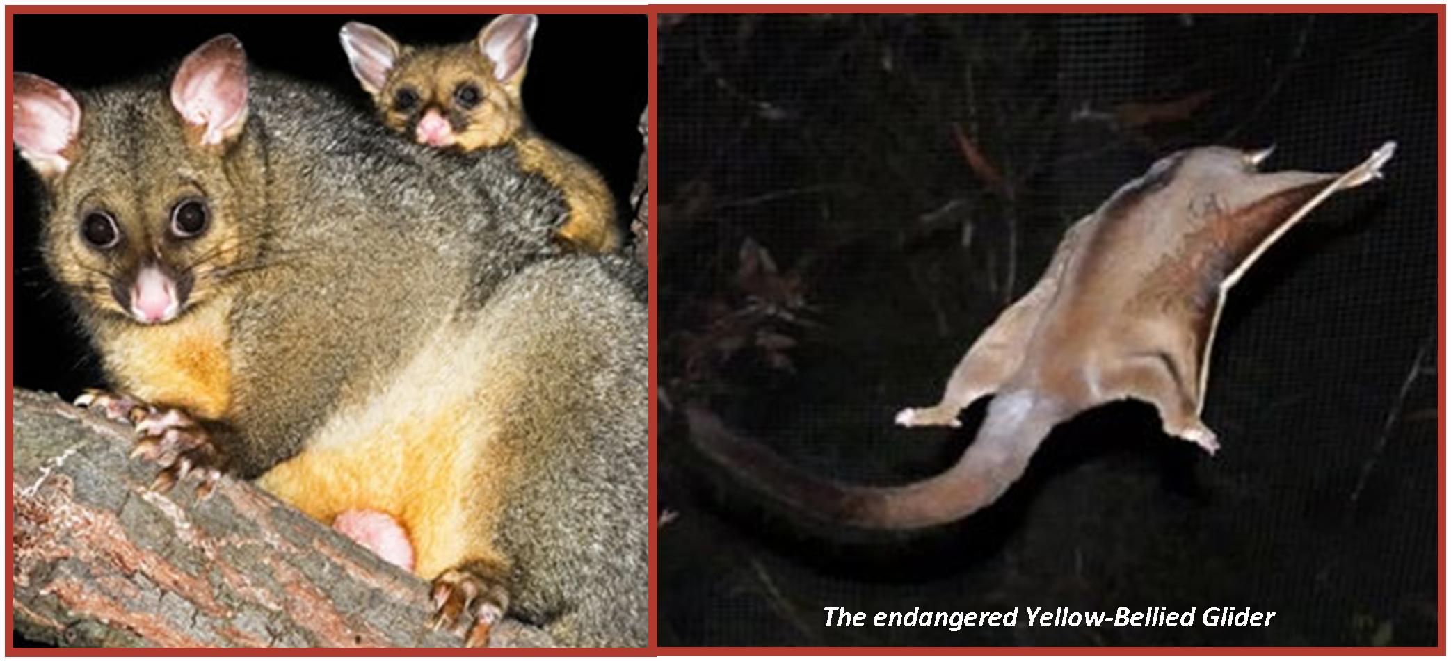
Mammals identified, or expected, in the area include the Eastern pygmy possum, Sugar glider, Brown antechinus, Bush rat, Common brushtail possum, Red -necked wallabies, Eastern grey kangaroo, Swamp wallaby, Grey-headed flying foxes and Rabbit. Around the creeks Wombats were abundant and evidence was found of Bandicoots, Echidna and European fox. Forty-three species of birds were recorded in the survey including evidence of a breeding pair of Grey goshawks. Superb lyrebirds, Turquoise parrots, Brown warblers, Variegated wrens and a high diversity and abundance of Honeyeaters, Lorikeets and Gang-gang cockatoos were considered to be significant features of the avifauna survey. Whilst no survey of reptiles and amphibians was conducted, casual observations were made of the Long-necked tortoise and two species of frogs.
One animal observed which is considered to be rare was the Yellow-bellied glider. It is possum-like with a body about 300mm and a tail about 430mm long. It has a gliding membrane extending from the wrist to the ankles and is mostly grey with the chest and belly creamy white to yellowish. Its diet consists of nectar, pollen, sap and insects including cicadas. The survey suggested that Platypuses were likely to be living in the creeks... (extract from Tomerong Local History)
The influx of Europeans into the area is estimated to have occurred no earlier than 1828. In 1828 there were over 36,000 people in the Colony of New South Wales. Almost 60 per cent of these were 'free'; that is, they were not convicts, free convicts or their descendants. Males outnumbered females by 3 to 1.
One indicator of who was living at Tomerong and when are Electoral Rolls. In 1841 the right to vote was available to any male over the age of 21 who, for one year, had occupied a house, warehouse, courtinghouse or ship of the annual value of £25. In 1850 the franchise was granted to the £10 householder. Females did not receive the right to vote until 1902 and Aboriginals until 1967... This table indicates the number of electors on the Tomerong electoral roll from settlement to 1928... (extract from Tomerong Local History)
| Year | Male | Female | Total |
|---|---|---|---|
| 1859 | 11 | - | 11 |
| 1870 | 39 | - | 39 |
| 1873 | 26 | - | 26 |
| 1876 | 35 | - | 35 |
| 1878 | 40 | - | 40 |
| 1885 | 57 | - | 57 |
| 1889 | 62 | - | 62 |
| 1892 | 72 | - | 72 |
| 1900 | 80 | - | 80 |
| 1903 | 73 | 49 | 122 |
| 1906 | 67 | 47 | 114 |
| 1908 | 72 | 52 | 127 |
| 1909 | 53 | 39 | 92 |
| 1913 | 58 | 49 | 107 |
| 1922 | 55 | 45 | 100 |
| 1925 | 50 | 48 | 98 |
| 1926 | 52 | 45 | 97 |
| 1928 | 45 | 39 | 84 |
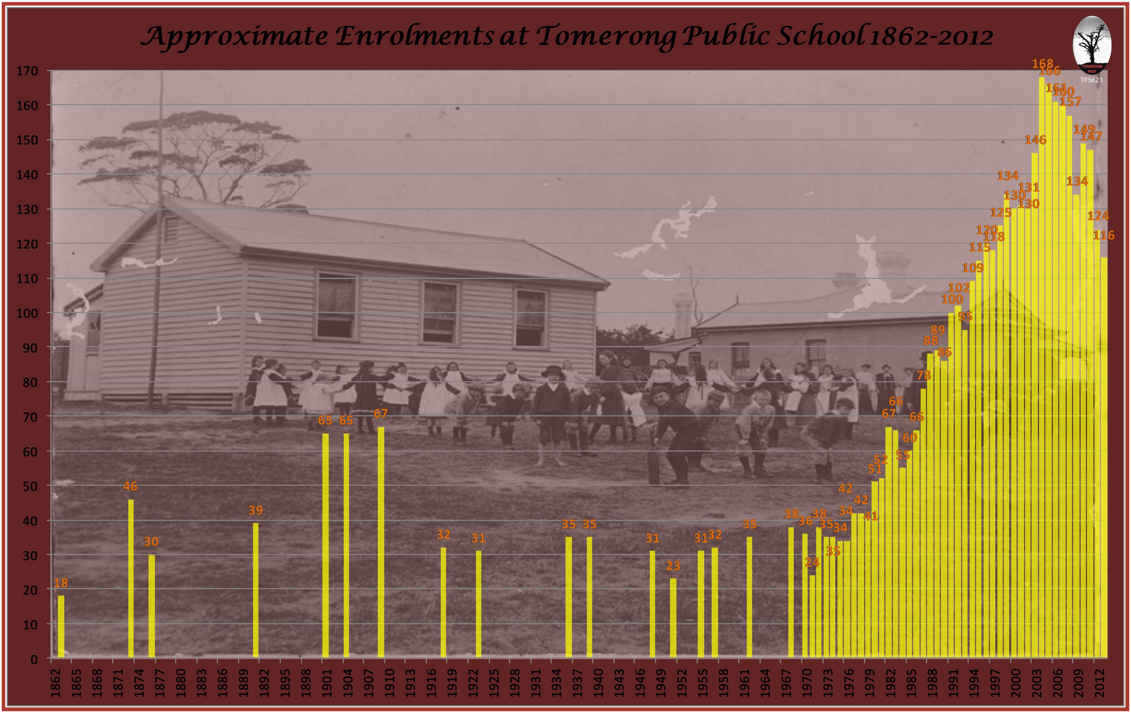
By the turn of the century much of the viable local land had become fully occupied. With large families and little local employment some family members moved north. The expiration of grazing leases in Queensland and northern NSW meant better quality land had become available and many of Tomerong's pioneering families genealogical records show branches stretching to these areas... Another indication of the variation of population in and around the village are the number of enrolments at Tomerong Public School. Whilst indicative; the figures would be influenced by the opening and closing of nearby schools and the number of children of timber workers who who were sometimes nomadic... (extract from Tomerong Local History)
Back to Top See the More Information page for additional information. The Next Page covers The Land.