
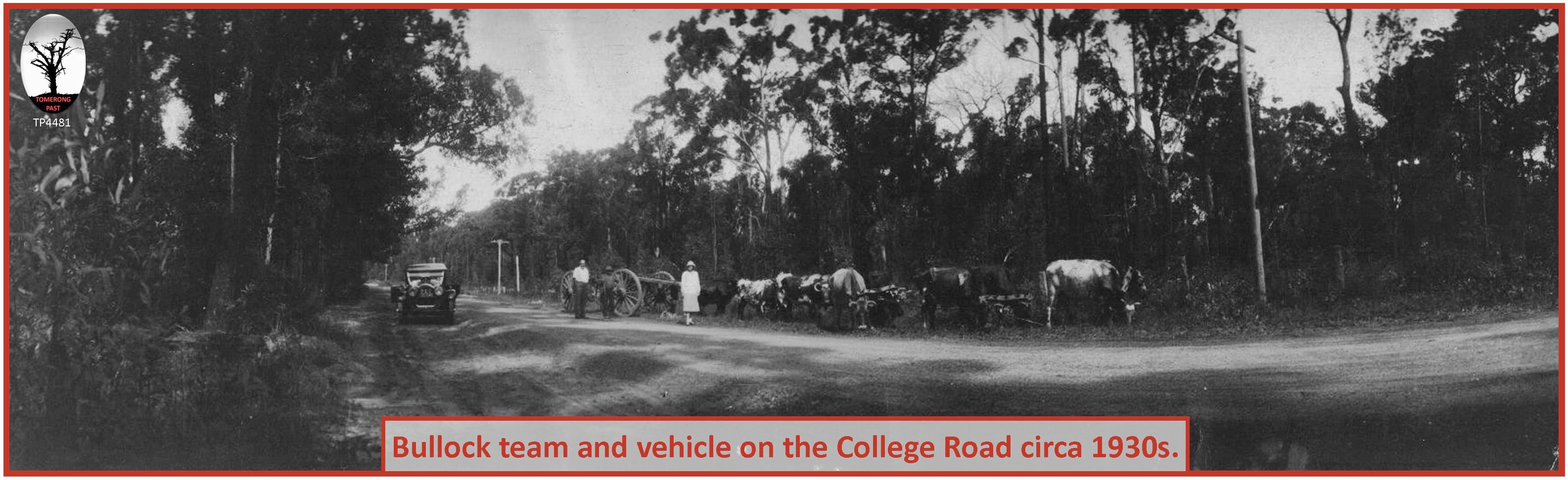
THE north south road through the village was initially referred to as the Shoalhaven to Ulladulla Road, followed by the Main South Coast Road and then the Prince's Highway. The Wool Road was an important early road from the Monaro to Jervis Bay passing south of the village, whilst the Turpentine to Jervis Bay, and later College Road, were important connections for the locals.
The opening up of inland New South Wales in the 1820s and the change from the land grant system to the sale of Crown Land enabled wool to play an important part in the Colony's development. Raising of sheep became a profitable enterprise and extensive grazing land was sought extending from Sydney over the Blue Mountains and also south to Goulburn and Lake Bathurst, situated between Lake George and the Shoalhaven River. Graziers were faced with a long overland journey to get their wool to market. A quicker and cheaper method would be to take their produce to the coast and then by ship to Sydney, if only a suitable overland route could be found. Charles Throsby and Hamilton Hume had already explored the area in 1821 and Throsby had reached Jervis Bay late in the year. He was satisfied that a road could be built from the tablelands to the Bay.
Lieutenant Robert Futter, George Galbraith, William Ryrie, James Holman, and two Aboriginal guides explored a route from Braidwood to Jervis Bay via Nerriga in October 1831, and in September 1839 J Murray of Yarralumba and a Mr O'Connell traversed a similar route. At this time any produce such as wool, hides, tallow and wheat had to be carted over poorly constructed tracks through the Southern Tablelands to Sydney for sale. It was hoped that a shorter route to Jervis Bay would enable transport using the sea, reducing costs and decreasing time. As a result of Murray and O'Connell's efforts the Governor was petitioned and in May 1840 Surveyor General Larmer commenced assessing the route.
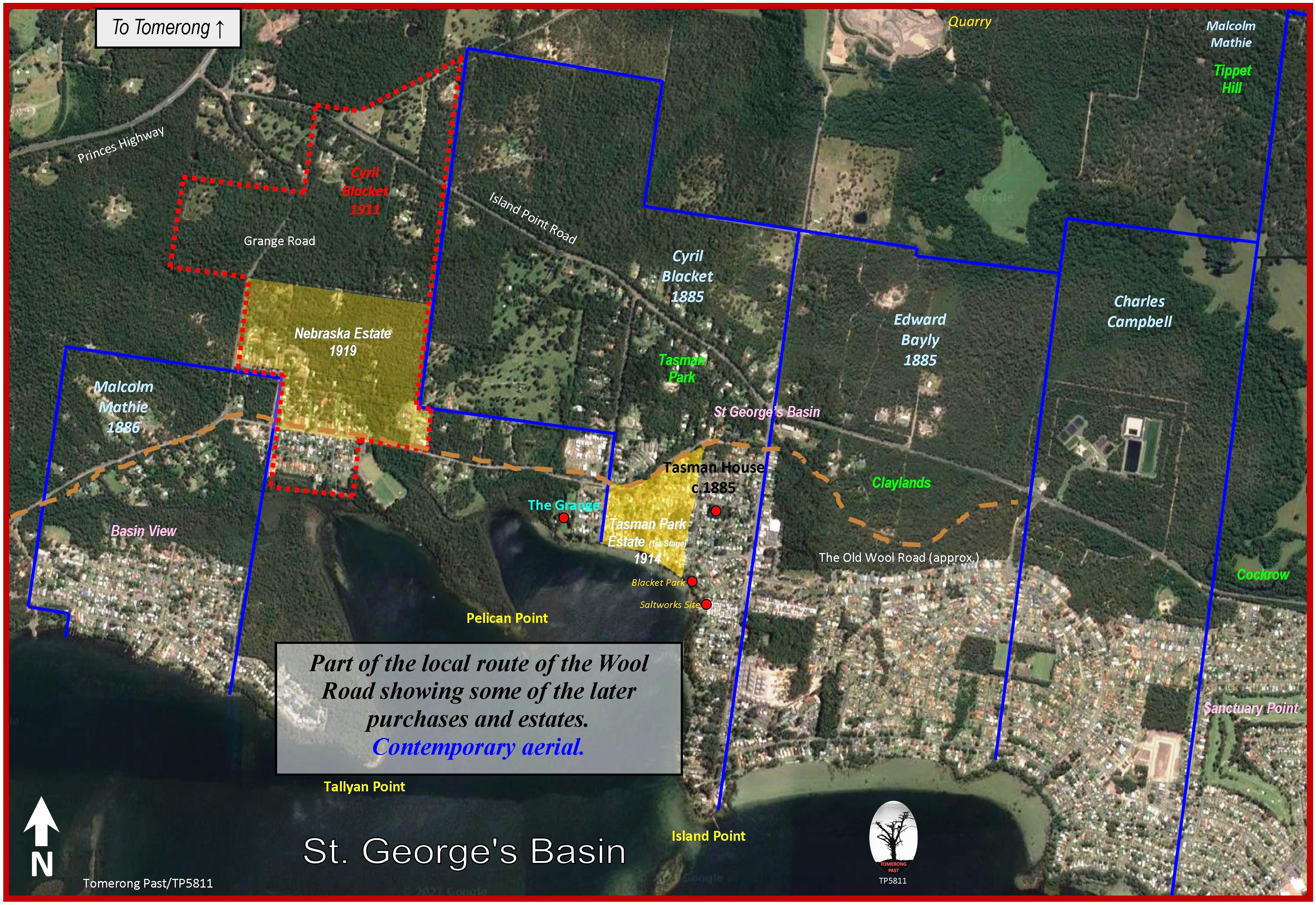
Larmer's map shows his surveyed route from Nerriga passed near Tianjara Falls, down Wandean Gap to 'Jeriwongela', and across Wandandian Creek following its northern bank around Bewong. The route continued east on the northern shores of St Georges Basin to 'Yerowle' (Erowal). From Erowal it went to South Huskisson (Vincentia) at the southern end of Collingwood Beach. Larmer created village reserves at Beulee (Nerriga), Yarrook Flat (West of Sassafras Mountain), Boolija (Boolijah), Jeriwongla (Jerrawangala) and near Berre Erre River (St Georges Basin).
The Wool Road was commenced in February 1841 with 70 convicts employed on its construction covering some 64 kilometres; they were supported by the ship Isabella that brought rations and implements from Sydney to Jervis Bay. The Gap, located beneath the Jerrawangala Lookout, was blasted from the sandstone escarpment to form the link to the coastal plain. The road was open for use by the first wool dray in October 1841.
The Wool Road brought some prosperity to the towns along its route, especially South Huskisson. Further towns were planned, some by developers and some by the government. New Bristol, near Hole-in-the-Wall on the southern shores of Jervis Bay, and Jervis Town, near Callala, were planned, subdivided and offered for sale in 1841 but with little success. In 1842 Farnham, originally called Jerrawangala, was planned on Crown Land south of the Wandean Gap on the Wool Road. Tianjara, near the falls and also on Crown Land, was planned in the same year but was never developed. By 1843 monthly steamer services were operating to Sydney but the Wool Road's popularity was beginning to decline. Many contributing factors led to this decline: shipping monopolies, Sydney merchants whose interest lay in shipping the wool from Sydney and not from Jervis Bay, the Sydney to Goulburn railway and inflated land prices at Jervis Bay. The development of the Sassafras-Tomerong-Nowra (Terara) road, the increasing importance of Nowra rather than Jervis Bay and a drought and depression in the early 1840s also would have contributed to the road's declining use. By 1848 South Huskisson and the Wool Road were returning to the bush from which they had begun.
The discovery of gold in the Braidwood and Nerriga areas led to an increase in local traffic and so demanded better lines of communication. In 1856 the current route from Nerriga to Sassafras was opened with the completion of the Endrick River bridge four kilometres north-east of Nerriga... (extract from Tomerong Local History)
The escarpment between Sydney and Illawarra made early road construction impractical; however, a cattle track was cut near Bulli in 1815 and by 1822 a new and better track was being used near Mount Keira. The road from Sydney was a circuitous route going via Liverpool, Appin and Bulli and was primarily to allow coastal grazing access for Southern Highlands graziers. The route from Appin to the coast was upgraded and re-routed about 1835 and a new route down Bulli Pass was improved in 1857. A more direct route from Sydney to the Illawarra was in operation from 1843. This road from Sydney crossed the George's River by punt at Lugarno, west of the current highway crossing, and then continued on to Bulli. The first wheeled vehicle did not travel this road to Bulli until 1868 after which the road became more popular than that via Appin.
These routes, or roads, connected with a coastal track which led as far as Saddleback Mountain just south of Kiama, then to Gerringong, and finally to Bomaderry in 1858. The building of the Shoalhaven River bridge in 1881 and the arrival of the railway at Bomaderry in 1893 cemented Nowra's importance… (extract from Tomerong Local History)
The 'Illawarra Mercury' reported in August 1859 that the inhabitants of Tomerong and Jerrawangala were raising a petition for the survey and clearing of a road to Jervis Bay. To gain access to markets any local produce had to be transported overland to the Shoalhaven River that was for some, 20 miles away. The waters of the Bay were just six miles away but without a suitable road. However, it wasn't until March 1861 that tenders were finally called. The road was to be constructed from Tomerong to the jetty at Jervis Bay (South Huskisson/Vincentia). It was to be one chain wide (20m); half a chain cleared and half a chain felled stump high. Tenders were to be for two mile lengths and addressed to Mr Parnell of the Traveller's Rest Hotel.
The 'Illawarra Mercury', in July 1863, contained an advertisement from the Department of Lands stating that, as no objections had been made, the parish road from Tomerong to the township of Huskisson would be opened and that claims for compensation would be received at either Nowra or Sydney.
By 1867 the road to Braidwood was under construction and it was reported that John Parnell intended to open an establishment for the purchase of butter, cheese and bacon for the Braidwood market.
A dispute arose between John Parnell and the Trustees of the South Huskisson Road (Tomerong to Vincentia) in the 1870s. At this time John Parnell was the owner and licensee of the Traveller's Rest Hotel situated at the junction of the Shoalhaven to Ulladulla Road and the South Huskisson Road. The dispute centred on whether the Trustees of the South Huskisson Road, Patrick Walsh, James Dent and Andrew Mackenzie, were adequately allocating the funding across the length of the road. More specifically, whether the Trustees were responsible for the road opposite on the western side of the main road (now called William Bryce Road and previously part of Turpentine Road).
John Parnell had purchased the land on the western side of Tomerong Creek, previously known as McGrath's farm, and had made repeated applications to the Trustees for the construction of a bridge across the creek, which they had refused. He called a public meeting where he displayed a plan that showed the South Huskisson Road extending west across the main road to the creek, which he believed qualified for funding. This map is believed to be the one surveyed and sent to the Surveyor General in December of 1860. It shows a surveyed road from Tomerong following the line of what is now Parnell Road directly to South Huskisson. An inquiry by the Trustees to the government resulted in the reply that '…the road for which the money was appropriated was that from the South Coast Road to Jervis Bay...''. This was not the end of the matter for in December 1871 a letter from the Department to the Trustees stated that '…application having been made to have the portion of the road westward from the South Coast Road proclaimed, the trustees were requested in the meantime to expend on it in judicious repairs so much of the trust funds as they might expedient'. Consequently the Trustees authorised the building of a bridge across Tomerong Creek and in 1873 additional funds were being expended in forming and maintaining the road west of the hotel. The Trustees felt that Mr Parnell had intervened to divert funds from the trust road to a bridge and road that was not proclaimed and where the main benefactor was himself. In a letter to the 'Shoalhaven News' in September 1873 Mr Parnell stated that the road from McGrath's corner to South Huskisson had been proclaimed, cleared and chained in 1860. In the same letter Mackenzie was accused of 'boiling-the-billy' with contracted maintainers of the South Huskisson Road and of leading the other Trustees 'by the nose'... (extract from Tomerong Local History)
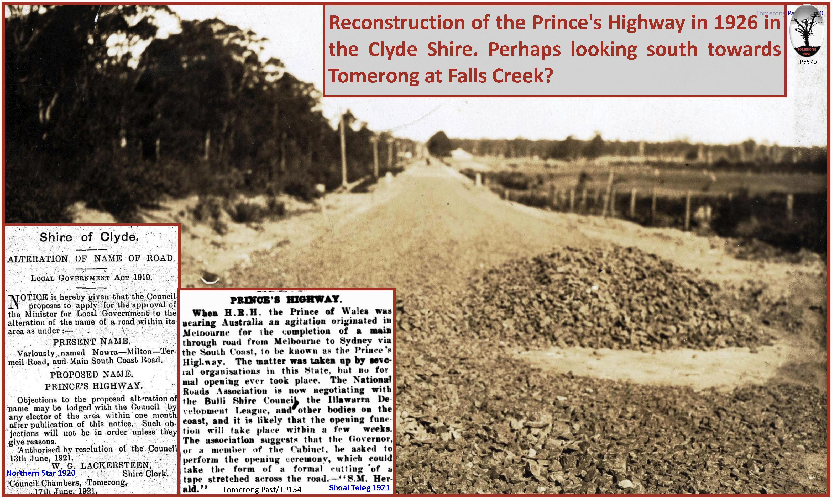
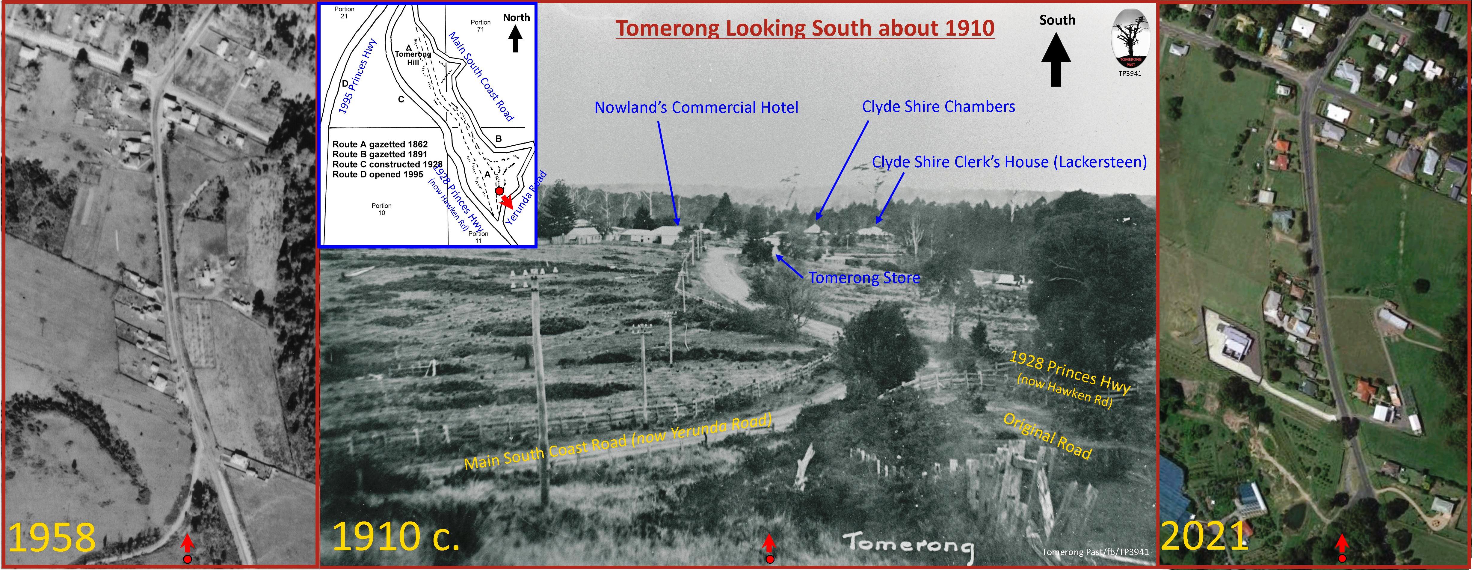
Prior to the Local Government Act of 1906 the State was divided into road districts with each having an officer in charge of both the roads and the bridges. With this act, control of the expenditure of grants for public roads passed from a centralised state run system to the local Shire and Municipal Councils. The Minister for Local Government was responsible for classifying the main roads, providing their funding and stipulating the actual annual expenditure for each, which was to be kept in repair by the appropriate Shire or Municipal Council. Tomerong was the headquarters of the newly proclaimed Clyde Shire Council and its main roads were the Main South Coast Road and the Braidwood to Nowra Road.
The transfer in responsibility of main road maintenance from the State Government to the Clyde Shire in 1906 coincided with the acceptance of the motor vehicle as a popular means of transport and by 1911 there was one vehicle for every 250 people in the State.
The new Council was responsible for all the roads within a vast area that was lightly populated. Initially it set about defining the route of the old Wool Road and closing some local roads that were no longer required. The road on the hill to Turpentine, just past Nelson's, was upgraded, as was the Wool Road from Erowal to Jervis Bay. On the Main South Coast Road work was concentrated on the road to Jerrawangala and straightening the deviation running east of Tomerong Hill.
In December 1910, possibly the first fatality involving a motor vehicle in Tomerong occurred on the Main South Coast Road. A sulky, driven by William Dent of Huskisson and containing his 14-year-old stepdaughter Myrtle Jennings, was travelling west on the Huskisson road en route to the Tomerong Store (Woodhill's) and approaching the Main South Coast Road junction adjacent to the Commercial Hotel. When the sulky was about 40 yards from the junction, a transport vehicle, parked alongside of the hotel and used for conveying passengers from Nowra to Milton, was started using the cars front starter handle. The sound of the vehicle starting startled the sulky's horse and a horse tethered in front of Woodhill's Store on the opposite side of the road. The horse pulling the sulky swerved onto the bank at the side of the road ejecting the driver. It then continued around the corner and down the road leading to Wandandian. About 100 yards from the junction the girl jumped or fell from the sulky. She was taken unconscious to Mr Lackersteen's residence (Bundor) to await the arrival of a doctor from Nowra but died later en route to hospital... (extract from Tomerong Local History)
An analysis of accident statistics between 1985 and 1987 revealed that the accident rate through the village of Tomerong on the Princes Highway was three times the State average. Most of these accidents occurred on the bends north of the village. One tragic accident occurred just south of the School of Arts in February 1987. A vehicle was turning off the highway into a driveway and was being followed by three other vehicles. A coach, travelling from Bomaderry to Eden with 32 passengers on board, came over the rise near the School of Arts and slammed into the stationary vehicles. One person from Sussex Inlet was killed, eight others from the cars and another four people on the bus were injured.
The accidents mainly involved non-residents as 70 per cent of the highway traffic was through traffic. Less than 2 per cent of the traffic that entered or left the village used Turpentine Road and a further 3.8 per cent used Pine Forest Road. About 8 per cent of the village traffic at this time consisted of heavy vehicles, which equated to 500 heavy vehicles passing through daily. Approximately 17 per cent of the traffic on the highway south of the village used the Grange Road. Whilst the average daily traffic count in 1986 was just over 6000 vehicles a day, this would often double in holiday periods.
The New South Wales Roads and Traffic Authority (RTA), formerly the Department of Main Roads, determined that a bypass would be the best option to improve road safety, reduce travel times, reduce vehicle operating costs and to improve the village as a residential community. The bypass would involve deviation from a 7.1 Km section of the highway in the Tomerong area. A community meeting was held to discuss the bypass on 7 September 1989 in the School of Arts with the majority of the community in favour of a bypass construction. An Environmental Impact Statement (EIS) was carried out by Mitchell McCotter and Roslyn Muston and Associates and exhibited between 12 June and 17 July 1990.
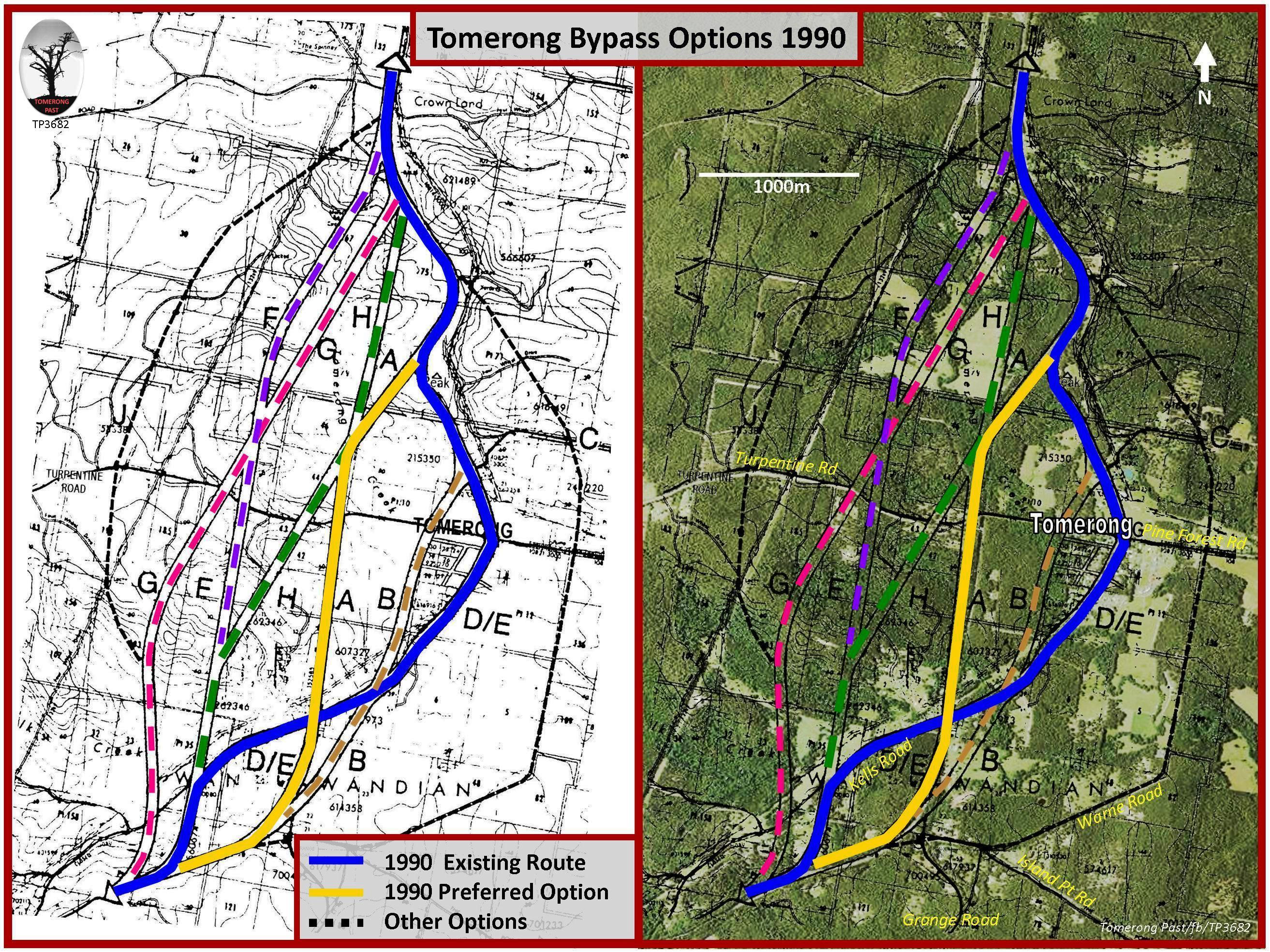
The RTA identified eight options for improving the highway at Tomerong. There were four options (F, G, H and J) which were up to 2.6 Km west of the village and west of the preferred option (A) which is now the current highway. Another option (B), almost half way between the current highway and the village, followed Hawken Road and Tomerong Creek more closely. A further option (C) swept 600m east of the village and crossed the Grange Road near its intersection with the undeveloped part of Island Point Road whilst another (D) involved upgrading of the existing highway. Whilst not a realistic option 'doing nothing' (E) was considered and used as a comparison of options for the EIS. The preferred route (A) was chosen and was estimated to cost $12M. As development of the project continued, several changes were made to the concept and the final estimate of cost was $22M… (extract from Tomerong Local History)
Back to Top See the More Information page for additional information. The Next Page covers Industry & Commerce.